About ArcGIS Earth
ArcGIS Earth is designed for everyone and provides user-friendly 3D experiences. Data support ArcGIS Earth allows you to use a variety of items from ArcGIS Online, ArcGIS Enterprise, local data, and web services: • Browse
ArcGIS Earth is designed for everyone and provides user-friendly 3D experiences.
Data support
ArcGIS Earth allows you to use a variety of items from ArcGIS Online, ArcGIS Enterprise, local data, and web services:
• Browse web scenes, map services, image services, scene services, and feature services.
• Browse local files including mobile scene packages (MSPK), KML, KMZ, tile packages, and scene layer packages (SLPK).
• Support has been added for Living Atlas of the World.
Key features
• Connect to ArcGIS Online or ArcGIS Enterprise.
• Tap to identify features.
• Support has been added for collecting, editing, and sharing placemarks.
• Interactive analysis tools include Measure, Line of Sight, and Viewshed.
• Create and share tours with geotagged photos.
• Search for places and switch locators.
• Start-up tips and guidance for hand gestures are included.
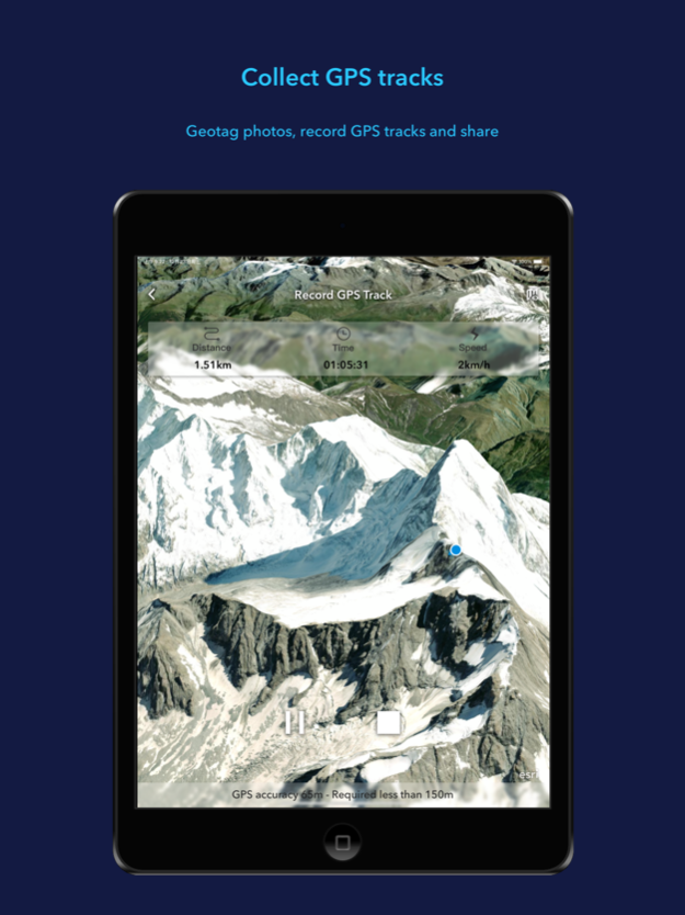
• Record and preview GPS tracks, and share with your organization.
Dec 14, 2023
Version 2.0
• Support for viewing underground data and setting ground transparency
• Support for drawing points, lines, and polygons, and sharing as a .kmz file. Drawings will be saved and managed in the Table of Contents Drawings tab
• Enhanced the tour experience. You can add placemarks (points) and geotagged pictures to the tour, customize views, and add text to waypoints
• Improved the geosearch experience and supported viewing and copying the result coordinates
Previous Versions
Here you can find the changelog of ArcGIS Earth since it was posted on our website on 2021-12-17 14:21:05.
The latest version is 2.0 and it was updated on 2024-04-22 08:39:56. See below the changes in each version.
ArcGIS Earth version 2.0
Updated At: 2023-12-14
Changes: Dec 14, 2023
Version 2.0
• Support for viewing underground data and setting ground transparency
• Support for drawing points, lines, and polygons, and sharing as a .kmz file. Drawings will be saved and managed in the Table of Contents Drawings tab
• Enhanced the tour experience. You can add placemarks (points) and geotagged pictures to the tour, customize views, and add text to waypoints
• Improved the geosearch experience and supported viewing and copying the result coordinates
ArcGIS Earth version 1.7.2
Updated At: 2023-04-29
Changes: Apr 29, 2023
Version 1.7.2
Fixed some bugs.
ArcGIS Earth version 1.7.1
Updated At: 2023-01-18
Changes: Jan 18, 2023
Version 1.7.1
Fixed some bugs
ArcGIS Earth version 1.6
Updated At: 2022-07-08
Changes: Jul 8, 2022 Version 1.6
- Support for measuring distance and area on the ground surface
- Support for measuring direct, vertical, and horizontal distances between two points in 3D scene
- Ability to view temporal data changing over time and control the time animation
ArcGIS Earth version 1.5.1
Updated At: 2022-04-21
Changes: Apr 21, 2022 Version 1.5.1
Fixed some bugs
ArcGIS Earth version 1.5
Updated At: 2022-03-03
Changes: Mar 3, 2022 Version 1.5
- Support for vector tile layer data type.
- Display data on a flat surface in the AR mode
- View details of Track statistics including speed and elevation profiles.
- Support for recording and visualizing GPS Tracks in 3D with z-value.
ArcGIS Earth version 1.4.2
Updated At: 2021-10-29
Changes: Oct 29, 2021 Version 1.4.2
• Fixed some bugs
Disclaimer
Official App Store Link
We do not host ArcGIS Earth on our servers. We did not scan it for viruses, adware, spyware or other type of malware. This app is hosted by Apple and passed their terms and conditions to be listed there. We recommend caution when installing it.
The App Store link for ArcGIS Earth is provided to you by apps112.com without any warranties, representations or guarantees of any kind, so access it at your own risk.
If you have questions regarding this particular app contact the publisher directly. For questions about the functionalities of apps112.com contact us.